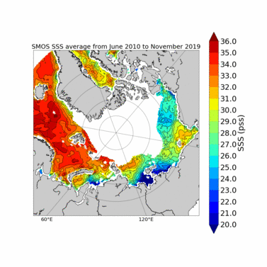
SMOS ARCTIC sea surface salinity fields available at CATDS
New weekly and monthly fields of SMOS SSS in the Arctic Ocean are available at CATDS (CEC-Locean L3 Arctic). They have been generated by the LOCEAN CATDS/CEC Ocean Salinity Expertise Center, in collaboration with LOPS, AARI and ACRI-st colleagues.
These maps over the Arctic Ocean are based on SMOS-ESA nominal level 2 SSS adjusted with SST corrections and sea ice filtering derived from SMOS retrieved pseudo dielectric constant. The SST corrections are performed using REMSS Microwave+Infrared Sea Surface Temperature (SST) optimal interpolation product.
The level 3 (L3) SMOS ARCTIC SSS (weekly and monthly) covers a period from June 2010 to November 2019 above 60°North. SSS values are reprojected in an Equal-Scalable Earth Grid 2 (EASE, https://nsidc.org/data/ease) with a Northern Hemisphere Azimuthal projection and a resolution of 25km.
7-day moving averages of SMOS ESA L2 parameters are produced each day for L3 SSS weekly product. An average considering each day of the month is computed for L3 SSS monthly product. Weekly and monthly uncertainties are estimated through an error propagation of SMOS ESA v662 L2 uncertainty estimates.
Feedbacks from users about the quality of these new products are very welcome, as they are experimental.
These new products are fully described in Supply et al 2020 (https://doi.org/10.1016/j.rse.2020.112027).
The dataset reference is https://www.seanoe.org/data/00607/71909/
Abstract of Supply et al. 2020
Since 2010, the Soil Moisture and Ocean Salinity (SMOS) satellite mission monitors the earth emission at L-Band. It provides the longest time series of Sea Surface Salinity (SSS) from space over the global ocean. However, the SSS retrieval at high latitudes is a challenge because of the low sensitivity L-Band radiometric measurements to SSS in cold waters and to the contamination of SMOS measurements by the vicinity of continents, of sea ice and of Radio Frequency Interferences. In this paper, we assess the quality of weekly SSS fields derived from swath ordered instantaneous SMOS SSS (so called Level 2) distributed by the European Space Agency. These products are filtered according to new criteria. We use the pseudo-dielectric constant retrieved from SMOS brightness temperatures to filter SSS pixels polluted by sea ice. We identify that the dielectric constant model and the sea surface temperature auxiliary parameter used as prior information in the SMOS SSS retrieval induce significant systematic errors at low temperatures. We propose a novel empirical correction to mitigate those sources of errors at high latitudes.
Comparisons with in-situ measurements ranging from 1 to 11 m depths spotlight huge vertical stratification in fresh regions. This emphasizes the need to consider in-situ salinity as close as possible to the sea surface when validating L-band radiometric SSS which are representative of the first top centimeter.
SSS Standard deviation of differences (STDD) between weekly SMOS SSS and in-situ near surface salinity significantly decrease after applying the SSS correction, from 1.46 pss to 1.28 pss. The correlation between new SMOS SSS and in-situ near surface salinity reaches 0.94. SMOS estimates better capture SSS variability in the Arctic Ocean in comparison to TOPAZ reanalysis (STDD between TOPAZ and in-situ SSS = 1.86 pss), particularly in river plumes with very large SSS spatial gradients.
more information and data access here.


