CEC-Locean L3 Arctic v1
SMOS Arctic SSS L3 maps produced by LOCEAN Expertise Center
Overview
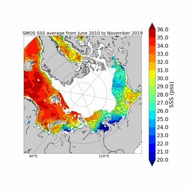
LOCEAN, LOPS, AARI and ACRI-ST have derived improved SMOS SSS maps over the Arctic Ocean based on new SST corrections and new sea ice filtering applied to SSS retrieved from SMOS satellite measurements.
The first version of level 3 (L3) SMOS ARCTIC SSS (weekly and monthly) covers a period from June 2010 to November 2019 above 60°North. The dataset is derived using uncorrected SSS from ESA SMOS SSS v662 level 2 (L2, https://smos.argans.co.uk/docs/deliverables/delivered/ATBD/SO-TN-ARG-GS-0007_L2OS-ATBD_v3.13_160429.pdf). SSS values are reprojected in an Equal-Scalable Earth Grid 2 (EASE, https://nsidc.org/data/ease) with a Northern Hemisphere Azimuthal projection and a resolution of 25km.
REMSS Microwave+Infrared Sea Surface Temperature (SST) optimal interpolation product (http://www.remss.com/measurements/sea-surface-temperature/oisst-description/) is used in order to correct SST related biases.
7-day moving averages of SMOS ESA L2 parameters are produced each day for L3 SSS weekly product. An average considering each day of the month is computed for L3 SSS monthly product. Weekly and monthly uncertainties are estimated through an error propagation of SMOS ESA v662 L2 uncertainty estimates.
Feedbacks from users about the quality of these new products are very welcome, as they are experimental.
Versions of the product:
V1.1 | generalization of bias correction using ACARD + sea ice filtering using ACARD + SST effects correction using REMSS SST (Methodology presented in "New insights into SMOS sea surface salinity retrievals in the Arctic Ocean »; Supply et al, 2020 ; https://doi.org/10.1016/j.rse.2020.112027) |
V1.0 | debiasing and sea ice filtering using ACARD + SST effects correction using REMSS SST |
References
Supply A., Boutin J., Vergely J.-L., Kolodziejczyk N., Reverdin G., Reul N., Tarasenko A., 2020. New insights into SMOS sea surface salinity retrievals in the Arctic Ocean. Remote Sensing of Environment, 249, 112027 (24p.), doi:10.1016/j.rse.2020.112027
Data References
Supply A., Boutin J., Vergely J.-L., Kolodziejczyk N., Reverdin G., Reul N., Tarasenko A. (2020). SMOS ARCTIC SSS L3 maps produced by CATDS CEC LOCEAN. SEANOE. https://doi.org/10.17882/71909
Data policy
The CATDS data are freely distributed. However, when using these data in a publication, please use the following reference and acknowledgement :
Supply A., Boutin J., Vergely J.-L., Kolodziejczyk N., Reverdin G., Reul N., Tarasenko A. (2020). SMOS ARCTIC SSS L3 maps produced by CATDS CEC LOCEAN. SEANOE. https://doi.org/10.17882/71909
Supply A., Boutin J., Vergely J.-L., Kolodziejczyk N., Reverdin G., Reul N., Tarasenko A., 2020. New insights into SMOS sea surface salinity retrievals in the Arctic Ocean. Remote Sensing of Environment, 249, 112027 (24p.), doi:10.1016/j.rse.2020.112027
"SMOS ARCTIC SSS L3 V1.0 maps have been produced by LOCEAN/IPSL (UMR CNRS/SU/IRD/MNHN) laboratory. AS is supported by a SU Ph. D. grant. This work was supported by CNES-TOSCA “SMOS-Ocean” and ESA “Expert Support Laboratory for L2 Ocean Salinity“ projects. AT acknowledges financial support from the Ministry of Science and Higher Education of the Russian Federation, project RFMEFI61619X0108."
Product access
HTTPS access
This research product is freely available on HTTPS:
https://data.catds.fr/cecos-locean/Ocean_products/SMOS_ARCTIC_SSS_L3_LOCEAN/
FTP access
This research products is freely available on FTP:
ftp ftp.ifremer.fr
user: ext-catds-cecos-locean
password: catds2010
chdir: Ocean_products/SMOS_ARCTIC_SSS_L3_LOCEAN
or ftp://ext-catds-cecos-locean:catds2010@ftp.ifremer.fr/Ocean_products/SMOS_ARCTIC_SSS_L3_LOCEAN (no longer works in the recent versions of most of the web browers)
Mailing list
If you want to register to our mailing list to be informed about major events, please send us a message at support@catds.fr (less than 10 messages / year).


