L4 Above Ground Biomass
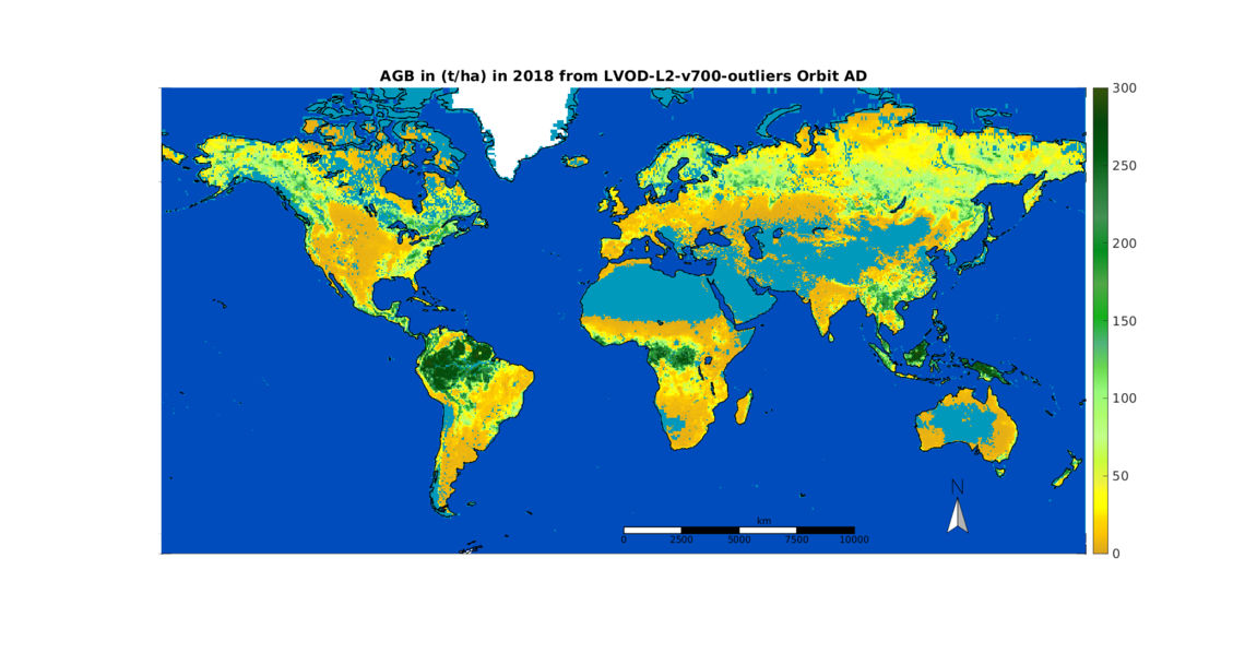
Monitoring Above Ground Biomass (AGB) is of prime importance to track the vegetation health and estimate the carbon stocks, among other applications. The Vegetation Optical Depth (VOD) derived from the multi-angular Brightness Temperatures (TB) measured by the Soil Moisture and Ocean Salinity (SMOS) mission can be processed in order to get a global AGB estimation.
Figure 1: Above Ground Biomass estimated with SMOS VOD, based on ESA CCI 2018
The AGB time series cover the life span of SMOS, i.e. 2011- 2024 at the moment.
SM_SCIE_MIR_L4AGBA version 6 is based on the ESA CCI version 5 AGB map
SM_SCIE_MIR_L4AGBB version 4 is based on the Avitabile et al. AGB map
SM_SCIE_MIR_L4AGBC version 1 is based on Neural Network and CCI AGB maps, version 5, years 2010/2016/2021
The estimated global and annual AGB maps and their uncertainties are freely provided as NetCDF files. Each file holds the AGB and associated std for all years covered by SMOS for a particular reference map. They are freely distributed by the CATDS - Centre Aval de Traitement des Données SMOS so that users can benefit from them in their studies on e.g. vegetation state monitoring, carbon stock estimation, land cover and land use or any other relevant topics.
Documentation
The file content description and the method are detailed in the technical note :
Boitard S. et al (2025). AGB estimation from SMOS LVOD, Issue 3.3, Technical note SO-TN-CB-GS-0108
Date : 2025/04/07
Data reference
Arnaud Mialon (2023). CATDS-CEC-SM L3 AGB Aggregated yearly global map of vegetation above ground biomass (AGB) obtained from SMOS' satellite optical thickness. CNES, IFREMER CESBIO(CATDS). doi:10.12770/95f76ff0-5d89-430d-80db-95fbdd77f543
Boitard, S., Mialon, A., Mermoz, S., Rodríguez-Fernández, N. J., Richaume, P., Salazar-Neira, J. C., Tarot, S., and Kerr, Y. H.: Aboveground biomass dataset from SMOS L-band vegetation optical depth and reference maps, Earth Syst. Sci. Data, 17, 1101–1119, https://doi.org/10.5194/essd-17-1101-2025, 2025.
J. C. Salazar-Neira, A. Mialon, P. Richaume, S. Mermoz, Y. Kerr, A. Bouvet, T. Le Toan, S. Boitard, and N. J. Rodríguez-Fernández, Above-ground biomass estimation based on multi-angular l-band passive microwaves brightness temperatures, IEEE Journal of Selected Topics in Applied Earth Ob-servations and Remote Sensing, vol. 16, pp. 5813-5827, 2023, doi: 10.1109/JSTARS.2023.3285288.
Product access
HTTPS access
This research products is freely available on HTTPS:
https://data.catds.fr/cecsm/Land_products/L4_Above_Ground_Biomass/
FTP access
This research products is freely available on FTP:
ftp ftp.ifremer.fr
user : ext-catds-cecsm
password : catds2010
chdir : Land_products/L4_Above_Ground_Biomass/
or ftp://ext-catds-cecsm:catds2010@ftp.ifremer.fr/Land_products/L4_Above_Ground_Biomass (no longer works in the recent versions of most of the web browers)
Mailing list
If you want to register to our mailing list to be informed about major events, please send us a message at support@catds.fr (less than 10 messages / year).


